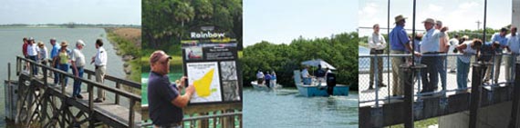
 From left: Lake Panasoffkee, Rainbow River, Clam Bayou and Tampa Bypass Canal
During the spring, the District has experienced an influx of new Governing Board members. This change in leadership has led to the need for informational tours throughout the District.
“Board members can read about a project or a water resource, but actually getting out to see a particular site to learn about it and ask questions of our staff gives our Board members a better understanding of the District’s role and responsibilities,” said Lou Kavouras, deputy executive director.
In addition to the number of new Board members, some major projects are under way or nearing completion, including the Lake Panasoffkee dredging project.
“After being involved with a project for years, many of our Board members are interested in seeing where the project is now,” said Kavouras.
Other projects are of interest because of the public’s heightened awareness of environmental issues, including conservation, land acquisition and water supply.
Here is a look at the four recent tours of Lake Panasoffkee, the Rainbow River, Clam Bayou and the Tampa Bypass Canal.
Lake Panasoffkee
The Lake Panasoffkee restoration project, one of the District’s largest restoration efforts, is nearing its final phase after ten years.
The restoration plan involves dredging nearly 7.8 million cubic yards of sediment from more than 1,741 acres of lake area to improve fish habitat, restore historic shoreline and improve navigation of the third-largest lake in west-central Florida. Approximately 920 acres of open-water habitat that have been lost to sedimentation and vegetation encroachment since the 1940s will also be restored.
To observe the Lake Panasoffkee restoration efforts firsthand, District staff and members of the District’s Governing Board, Withlacoochee River Basin Board and Lake Panasoffkee Restoration Council recently toured the project site.
“What was a vision ten years ago, when the Lake Panasoffkee Restoration Council was created by the Legislature, will soon be a reality,” said Mike Holtkamp, District operations director. “By early this fall, the dredging of the lake will be completed and the lake will have been restored to the condition that existed in 1940.”
In 1998, the state Legislature created the Lake Panasoffkee Restoration Council to develop a restoration plan for the lake. Since then, the Council has been reporting to the Legislature on an annual basis, providing progress reports on the restoration plan’s development and implementation.
Rainbow River
The District is continuing its effort to protect the water quality in the Rainbow River as plans for a new community park come to life.
The City of Dunnellon and Marion County recently acquired 33 acres of land adjacent to the Rainbow River to build a large-scale community park called Blue Run. The park will offer an improved tube and kayak exit, parking areas, bathrooms, picnic shelters and walking trails with associated exhibits and educational kiosks for the public.
The District has been asked to fund three components of this project in fiscal year 2009, which will address stormwater treatment and provide water resources education.
Members of the District’s Governing Board and Withlacoochee River Basin Board, and representatives from the City of Dunnellon, Marion County and Rainbow River Conservation, Inc., recently toured the site to learn about the project.
The District’s project components include improving the existing limerock park-ing lot and associated stormwater management system, improving an existing tube and kayak exit, and providing educational signage throughout the park.
Currently, the site’s parking lot offers little stormwater treatment. To avoid stormwater runoff from entering the river without being treated, the parking lot will be improved with a permeable or pervious surface to capture and treat storm water prior to discharging into the Rainbow River.
In addition, a boardwalk will be built to alleviate an erosion problem associated with the existing tube and kayak exit.
The District will also assist in the development of educational signage throughout the park to inform visitors about water resources.
This project has been tentatively approved by the Withlacoo-chee River Basin Board for inclusion in its fiscal year 2009 budget. Staff will request final approval from the Basin Board in August and from the Governing Board in September.
Clam Bayou
District Governing Board and Pinellas-Anclote River Basin Board members recently toured Clam Bayou with staff to learn about the District’s Surface Water Improvement and Management (SWIM) water quality improvement and habitat restoration projects for the bayou.
Clam Bayou is a 90-acre estuary system located off the eastern reaches of Boca Ciega Bay in Tampa Bay, which is one of the ten SWIM priority water bodies.
“Clam Bayou is one of the last naturally functioning estuaries on Boca Ciega Bay,” said Jennette Seachrist, SWIM program manager. “The District and the cities of St. Petersburg and Gulfport are working together to implement projects that will improve the quality of storm water entering Clam Bayou from the surrounding watershed and will create habitat.”
The Clam Bayou stormwater treatment and habitat restoration project is a multiphase project that began in 1994. The first two phases, completed in 1995 and 2001, restored 20 acres of coastal habitat, created park lands and provided stormwater treatment in portions of Clam Bayou within Gulfport and St. Petersburg.
The third phase of the Clam Bayou project is currently being designed and construction is expected to begin in 2009. This phase includes three large stormwater ponds to treat 2,600 acres of highly urbanized stormwater runoff from St. Petersburg and Gulfport. The ponds will filter the water to remove sediments, trash and pollution prior to discharging into Clam Bayou. The project will also create habitat for fish and wading birds by removing fill and creating intertidal lagoons. Treated runoff from the stormwater treatment ponds will provide a source of fresh water to the intertidal areas, critical for supporting fish nurseries. The treated storm water will also improve circulation in the bayou.
Tampa Bypass Canal
In April, Governing and Basin Board members, staff, and representatives from the U.S. Army Corps of Engineers toured the Tampa Bypass Canal, which is the largest and most visible flood control facility managed by the District.
Like other major structural flood control facilities, this system consists of a large detention area that temporarily stores floodwaters during periods of heavy rainfall and then diverts the floodwaters around the cities of Temple Terrace and Tampa through a system of water control structures and canals.
The tour began in the Trout Creek Park and then continued through the Lower Hillsborough Wilderness Park, both of which are located within the Lower Hillsborough Flood Detention Area. Each year more than 1.5 million people visit the parks, which are managed by the Hillsborough County Parks, Recreation and Conservation Department and serve as a flood detention area when needed.
Trout Creek Park is located immediately upstream from the S-155 structure, which is the structure on the Hillsborough River that is closed to impound floodwaters during extreme storm events. Stored floodwaters are then diverted to the south around Temple Terrace and Tampa through the Tampa Bypass Canal.
The group also stopped at the S-162 structure. This is the location where the District, as part of the Tampa Bypass Canal Diversion Project, is pumping 11 cubic feet per second (cfs) of water, or 7.1 million gallons per day (mgd), from the lower pool of the Tampa Bypass Canal to the middle pool of the canal, and then to the Hillsborough River Reservoir. In turn, 8.25 cfs, or 5.3 mgd, is being pumped from the reservoir to the base of the dam into the lower Hillsborough River.
This is the first project that has been implemented in the District’s Lower Hillsborough River Recovery Strategy, which is designed to meet the new minimum flows.
A minimum flow or level is the limit at which further water withdrawals will cause significant harm to the water resources and related environment. The new minimum flows for the lower Hillsborough River are 24 cfs during April–June and 20 cfs the remainder of the year. An independent, scientific peer review panel reviewed the new flows, which are at least twice the previous minimum flow of 10 cfs.
The new minimum flows must be met by 2017. With the addition of the Tampa Bypass Canal Diversion Project, the District is now meeting about 80 percent of its goal, or about 18.25 cfs.
The final stop on the Tampa Bypass Canal tour was the S-161 structure. This is the most operated structure during a storm event.