About the Watershed Management Program
The District takes a watershed approach to managing water and water-related resources within its boundaries. By doing so, all the characteristics of each watershed can be evaluated to reflect the real, interconnected nature of Florida’s water resources. This increases the District’s ability to clearly identify, prioritize and address issues related to the area’s water resources. The Watershed Management Program provides a method to evaluate the capacity of a watershed to protect, enhance and restore water quality and natural systems while achieving flood protection.
This program provides five major elements:
- Topographic information
- Watershed evaluation
- A watershed management plan
- Implementation of best management practices
- Maintenance of watershed parameters and models
For additional information about the District’s comprehensive approach to watershed management, view or download our Watershed Management brochure.
Floodplain Map Viewer
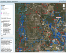
The Southwest Florida Water Management District, in cooperation with local governments, is developing flood risk information for watersheds throughout west-central Florida. The floodplain map viewer is an interactive tool that allows you to view flood risk information that has been developed to date as part of the District’s Watershed Management Program. The information is provided as an advisory tool for flood hazard awareness and to present preliminary floodplain results for public review and comment. Once finalized, the flood hazard information will be used by the District as the most appropriate information for environmental resource permitting and will, in the future, be used to revise the Federal Emergency Management Agency’s (FEMA) Flood Insurance Rate Maps (FIRMs).
If you do not know which watershed you live in, you may submit an address using the watershed search tool to find out.
To access this useful tool, proceed to the Floodplain Map Viewer and find your county and watershed. First time using the map viewer? Check out the Quick User's Guide.
What is a flood map?
A flood map is a risk assessment tool used to help determine the different flooding risks in a community. The most current maps, called Digital Flood Insurance Rate Maps, depict high-, medium- and low-risk zones (25-30 percent of all flood claims come from moderate- to low-risk flood areas).
View Floodplain Map Viewer »
Public Meetings
As preliminary flood risk information is developed for a watershed, the District is conducting public meetings so that citizens can learn about the data and science used to determine the flood hazard areas, view the preliminary floodplain results and have an opportunity to ask questions and provide comments. Upcoming meetings will be posted here (by watershed) and in local newspapers.
What is a watershed?
A watershed is an area of land that water flows across as it moves toward a common body of water, such as a stream, river, lake or coast. Learn about our Watershed Management Program
What is a floodplain?
Part of every watershed, a floodplain is a dry or semi-dry land area where water collects when it rains.
- Typically found near rivers, lakes, coasts and depressions
- Provides temporary natural storage for runoff
- Serves as recharge areas for the aquifer
- Provides important natural habitats for animals and plants
Vertical Datum Upgrade »
Learn why the District is currently upgrading the datum used to record water level elevations