Search Content
Displaying results 1 - 20 of 2166
Highlights
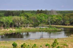
- Home to the fourth largest spring in the state of Florida, Rainbow Springs
- Discharges an average of 493 million gallons of water per day into the Withlacoochee River
- Designated an Outstanding Florida Water and an Aquatic Preserve
- Located in Marion and Citrus counties
- 73-square-mile watershed
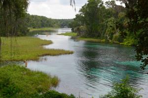
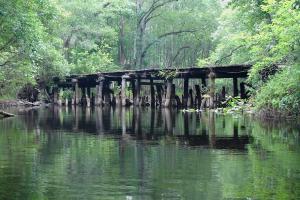
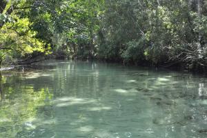
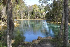
Rainbow Springs is known for its outstanding water clarity and is popular for swimming and paddling. About the SpringsThe Rainbow River is a first-magnitude spring system originating in Marion County. Rainbow Springs is the headwaters of this short, freshwater river flowing nearly 6 miles from the headsprings to where it meets the Withlacoochee River. …
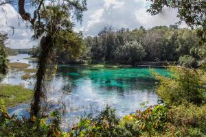
The Rainbow River in Marion County begins at Rainbow Springs in the town of Dunnellon and makes its way 5.7 miles until it merges with the Withlacoochee River. The Withlacoochee River ultimately discharges into the Gulf of America on the border of Citrus and Levy counties.Rainbow Springs has the fourth largest flow of all Florida’s springs and provides fresh water to the Rainbow and Withlacoochee rivers. The…
This project helped develop techniques to control algae and restore aquatic plants in the lower portion of the Rainbow River.BackgroundIn the lower portions of the Rainbow River, native aquatic vegetation may be decreasing while various types of algae, such as filamentous macroalgae (Lyngbya) and phytoplankton, may be increasing. An increase in algae downstream is typical in most rivers as the river’s velocity — the speed at which water flows — decreases and water…
Four rivers impressively emerge from the Green Swamp. They are the Hillsborough, Withlacoochee, Ocklawaha and Peace rivers. These rivers provide much of central Florida’s water supply. Check out these stats and visit our other virtual watershed excursions to learn more about these rivers.Hillsborough River
- Total length: 55 miles
- …
KarstMuch of Florida’s landscape is composed of “karst” landforms. Karst terrain is a land surface produced when bedrock — mostly limestone in Florida — dissolves slowly over time as acidic rainwater passes through it. Karst terrain provides a direct connection between surface waters and groundwater and is characterized by springs, sinkholes and caverns.Springs Springs are a common feature of karst topography. They also serve as key tributaries of the…
The initiative was designed to better understand the dynamics of the river and watershed, identify how alterations have affected the system, and evaluate alternatives to better manage the water resources. STATUS UPDATE: A peer review of the Withlacoochee River Model was completed in 2020. This peer review concluded that the model results and conclusions are accurate and can be relied upon for resource management and understanding of this complex river…
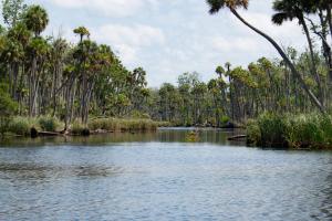
Join us in the community effort to protect the Weeki Wachee River. The Weeki Wachee River is a great place to experience natural Florida. This river flows 7.4 miles from the headspring to where it meets the Gulf of America at Bayport in Hernando County. It’s a popular spot for kayaking and boating. But increased recreational activities have had negative environmental impacts on the river. Here are some ways you can recreate responsibly and…
River Model Scenarios
Nineteen scenarios have been identified through years of meetings and workshops with external stakeholders, special interest groups and residents. These scenarios are being tested by the model to show how historical alterations have affected the river and watershed. They include:
- Five scenarios in the Green Swamp…
Highlights
- The lower half of the river is part of the more than 31,000-acre Chassahowitzka National Wildlife Refuge
- Designated an Outstanding Florida Water
- Located in Citrus County
- 190-square-mile springshed
- Ecological shifts in the river caused by sea level rise, coupled with the decline of spring discharge primarily due to a long-term decrease in…
The District facilitated five public workshops during the open comment period for the draft Withlacoochee River Watershed Initiative scenarios report. Stakeholder groups and residents were invited to the workshops listed below.
- April 23, 2015: DADE CITY – Pasco High School from 4:30-7:30 p.m.
- April 30, 2015: BUSHNELL – South Sumter High School from 4:30-7:30 p.m.
- May 7, 2015: INVERNESS – Cornerstone Baptist Church from 4:30-7:30 p.m.
- May 13,…
Your Questions AnsweredSeptember 2018Q: Why is the Withlacoochee River experiencing flooding again this year?A: Throughout the spring and summer, above average rainfall has saturated soils and filled wetlands and swamps that are no longer able to store additional rainfall.Q: Is river flooding a normal occurrence?A: …
Your Questions AnsweredJuly 2019The Withlacoochee River is one of the longest and most scenic rivers in the state. As Florida’s third largest river that winds through eight counties, there are many myths about this mighty river. Mark Fulkerson, Ph.D., P.E., Senior Professional Engineer, clarifies some common misconceptions about this 160-mile waterway.Q: Why does the Withlacoochee River run north? Don’t most rivers flow south?A…
Highlights
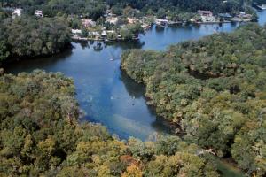
- Homosassa Springs is the headwaters of the Homosassa River and is known as the Homosassa Springs State Wildlife Park
- The park serves as a rehabilitation center and refuge for orphaned or injured manatees.
- Located in Citrus County
- 270-square-mile springshed
Highlights
- Weeki Wachee Springs are the headwaters of the Weeki Wachee River
- The headspring is home to Weeki Wachee Springs State Park, which features a water park and the famous underwater mermaid show
- Located in Hernando County
- First magnitude spring: 260-square-mile springshed
- Potential decrease in historic flows
- Elevated…
In 1987 the Florida Legislature created the Surface Water Improvement and Management (SWIM) Act to protect, restore and maintain Florida's highly threatened surface water bodies. Under this act, the state's five water management districts identify a list of priority water bodies within their authority and implement plans to improve them. The District's SWIM Program The Southwest Florida Water Management District's Surface Water Improvement and Management…
A spring is a place where groundwater discharges from the underlying limestone bedrock to the Earth's surface through a natural opening in the ground. In the Springs Coast Watershed, the Floridan aquifer is close to the land surface, which means that the springs are exposed portions of the aquifer! As windows into the aquifer, springs have long been one of Florida's most valued natural and scenic resources. In 1513, the Spanish explorer Ponce de Leon came to Florida in…
Your Questions AnsweredNovember 2021Florida has the largest concentration of springs in the world, with more than 200 springs within the boundaries of the Southwest Florida Water Management District. These natural wonders rely on rainfall to replenish their water source, and Dr. Madison Trowbridge explains how the rainy season provides big benefits for Florida’s springs.Q: What is spring flow?A: Spring flow is the amount of water that…