Search Content
Displaying results 181 - 200 of 5027
Your Questions Answered
December 2020
Q: What does data collection mean?
A: Data collection is the process of gathering, measuring and analyzing specific information to fix a problem. District geologists perform data collection to help answer scientific and engineering questions in managing water supplies, preserving natural systems and protecting against flooding. The District's Data Collection Bureau…
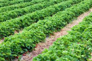
Stormwater SystemsA stormwater system is designed to collect and manage runoff from rainwater. They are specifically designed to help prevent flooding and remove pollutants from the water, and they are required for most new development since the 1980s. When rainwater lands on rooftops, parking lots, streets, driveways and other hard surfaces, the rainfall that doesn’t soak into the ground is called stormwater runoff. Stormwater runoff carries pollutants such as litter…
February 2025Q: What is an invasive species?A: An invasive species is an organism that does not naturally occur in a specified geographic area, has been introduced intentionally or unintentionally by humans, and either does or could harm the environment, economy or human health. Invasive species pose a significant threat to Florida's ecosystems by impacting water quality, native habitats and biodiversity. Both aquatic and…
January 2023
Q: What is vegetation management?
A: Vegetation management is the targeted control of nuisance and invasive exotic vegetation. These operations are conducted on both District-owned lands and on District-managed public waterbodies. This includes the control of both aquatic vegetation, growing in or near water, and terrestrial vegetation, growing on land.
Q: Why is vegetation management important…
In 1987 the Florida Legislature created the Surface Water Improvement and Management (SWIM) Act to protect, restore and maintain Florida's highly threatened surface water bodies. Under this act, the state's five water management districts identify a list of priority water bodies within their authority and implement plans to improve them. The District's SWIM Program The Southwest Florida Water Management District's Surface Water Improvement and Management…
Highlights
- Weeki Wachee Springs are the headwaters of the Weeki Wachee River
- The headspring is home to Weeki Wachee Springs State Park, which features a water park and the famous underwater mermaid show
- Located in Hernando County
- First magnitude spring: 260-square-mile springshed
- Potential decrease in historic flows
- Elevated…
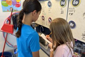
Fourth and fifth graders at Lutz K-8 School recently toured the school with clipboards in hands. Their mission: to find ways to save water in the school. The classroom project was part of a Splash! grant the school received from the Southwest Florida Water Management District (District) to help students learn how to protect water resources through a variety of ways like water conservation. On this day, students conducted a water audit of the school to improve water…
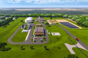
About the FARMS ProgramFARMS is an agricultural cost-share reimbursement program that reduces groundwater withdrawals from the Upper Floridan aquifer through conservation and alternative water supply best management practices (BMPs). In conjunction with water conservation BMPs, water quality and natural systems improvement BMPs also may be cost-shared in priority areas.The program is designed to serve as an incentive to the agricultural community to promote water…
Learn more about District Planning Regions on our Regional Water Supply Plan page.
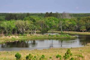
Sinkholes are a common naturally occurring geologic phenomenon and one of the predominant land forms in Florida.Many of the lakes in Florida are relic sinkholes. Sinkholes can be classified as geologic hazards sometimes causing extensive damage to structures and roads resulting in costly repairs. Sinkholes can also threaten water supplies by draining unfiltered water from streams, lakes and wetlands directly into the aquifer (underground water supply). What if a…
Highlights
- Largest natural lake in Hillsborough County with a surface area of greater than 800 acres
- Popular for recreational use as it is one of the few natural lakes in the area with public access
- Discharges into the Hillsborough River which is used for municipal water supply for the City of Tampa
- Nutrient loadings from the watershed have caused extreme…
Your Questions Answered
March 2022
Q: Is there a rainy season and dry season in central Florida?
A: Yes, rainfall is seasonal. Our rainy season is a four-month period from June through September, with average rainfall of about 7.8 inches each month. About 60 percent of our average annual rainfall is received during that time. The higher rainfall results in rising water levels in wells, lakes, rivers and springs…
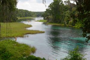
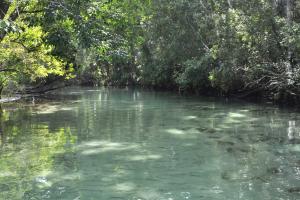
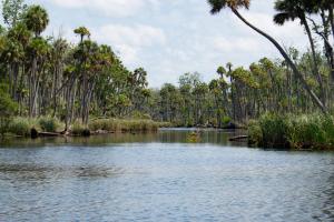
Rainbow Springs is known for its outstanding water clarity and is popular for swimming and paddling. About the SpringsThe Rainbow River is a first-magnitude spring system originating in Marion County. Rainbow Springs is the headwaters of this short, freshwater river flowing nearly 6 miles from the headsprings to where it meets the Withlacoochee River. …
Florida law requires establishment of minimum flows and levels of water bodies to prevent significant harm associated with water withdrawals.Program overviewFlorida law (Chapter 373.042, Florida Statutes) requires the state water management…
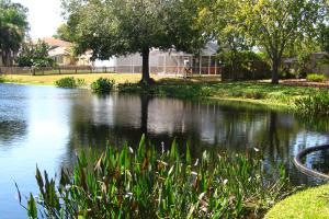
Your Questions AnsweredOctober 2021Record amounts of rainfall in some areas over the summer has highlighted the importance of stormwater ponds to help prevent flooding and improve water quality throughout the region. You may have seen stormwater ponds throughout neighborhoods and commercial developments in Florida but might not know about their purpose as many people often mistake stormwater ponds for natural water bodies. Southwest Florida Water Management…
The Southwest Florida Water Management District’s (District) Governing Board voted in December to approve the 2025 Regional Water Supply Plan (RWSP), providing a framework for future water management decisions and demonstrating how growing water demands can be met through 2045. The RWSP identifies sufficient water supplies to meet the growing needs of the 16-county area using a combination of alternative water sources, fresh groundwater and water conservation measures.…
Wetlands »
Your Questions Answered
November 2019
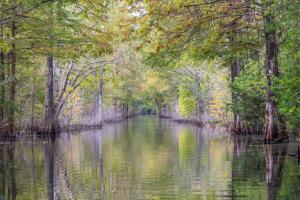
We often receive questions from the public about wetlands and why they are important. Tasha Dailey is certified as a Professional Wetland Scientist by the Society of Wetland Scientists and explains why wetlands are a critical part of our natural environment.
Q: What is a wetland?
A: A wetland is a distinct ecosystem that is flooded by water, either permanently or seasonally, where…
Highlights
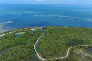
- The lower half of the river is part of the more than 31,000-acre Chassahowitzka National Wildlife Refuge
- Designated an Outstanding Florida Water
- Located in Citrus County
- 190-square-mile springshed
- Ecological shifts in the river caused by sea level rise, coupled with the decline of spring discharge primarily due to a long-term decrease in…
Highlights
- Designated an “Estuary of National Significance” in 1987
- Surface area of approximately 52 square miles
- Includes Manatee and Sarasota counties
- 150-square-mile watershed