Search Content
Displaying results 841 - 860 of 4140

Biking »
From the novice to the expert trails, many different types of biking opportunities can be found on District lands.BikingWilderness Park Off Road Trails System at Lower Hillsborough Wilderness Preserve

The District offers many recreational opportunities for everybody to get outside.The District and its partners provides recreational opportunities for the mobility-impaired. Many of the lands listed in this guide have accessible facilities such as paved trails, boardwalks, fishing piers, picnic areas or restrooms that meet the standards established by the ADA. The District also provides opportunities for mobility-impaired fishing and hunting on some areas…
The Southwest Florida Water Management District (District) offers this page as a means of providing our partners and cooperators our logotype and seal.We’ve organized files based on the file formats typically preferred by home/office software and professional graphics software. Please contact our webmaster for…

To conserve water means to use it wisely and to not be wasteful. Conserving water is a very important part of making sure there is enough water to meet the needs of humans and the environment. And even though we might have enough fresh water available to meet our needs today, we also need to plan for the future.
The Southwest Florida Water Management District (District), along with other local governments and organizations, are responsible for managing…
Highlights
- Designated an “Estuary of National Significance” in 1990
- Florida’s largest open-water estuary at 373 square miles
- Over 2.7 million residents in the watershed
- Includes portions of Hillsborough, Manatee and Pinellas counties
- 2,200-square-mile watershed
- Update nutrient reduction goals for each bay segment using a revised seagrass-nutrient management paradigm…
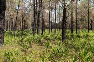
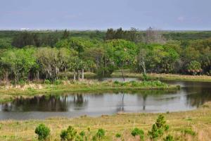
The District adopts plans to ensure its public conservation lands are used and managed in ways that are consistent with Florida Statutes and the District’s mission.District lands are open to the public and community input is vital in determining how these lands are managed and used. Each of the following plans includes the natural resource and public use strategies and objectives established for these lands over the 10-year period for which they cover.Land…
Project Overview
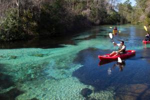
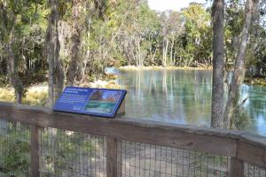
An ecologically-based study was completed to evaluate how recreational use affects natural systems along the Weeki Wachee River in Hernando County, Florida. The study, known as a carrying capacity study, is intended to provide information to assist in making decisions that will better manage impacts of recreational use on this natural system.
Background
The beauty of the river makes it a popular site for recreational activities. There are…
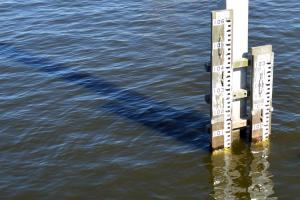
To improve accuracy, the Southwest Florida Water Management District (District) has upgraded the datum used to record water level elevation. The District has upgraded the datum, or starting point, used to record water level elevation at its data collection sites. Water elevation is measured in feet above mean sea level. The datum was upgraded from the National Geodetic Vertical Datum of 1929 (NGVD 29) to the North American Vertical Datum of 1988 (NAVD 88…
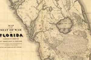
Sometime in the early 1500s — an unknown Spanish cartographer was updating a map of the New World. He sketched a meandering river in a previously uncharted region. Like all cartography, it was part accurate representation, part educated guess. Perhaps out of wishful thinking, he decided to call it Rio de la Paz, or the “Peace River.”To the Seminole Indians, who settled on its banks two centuries later, it was Tallackchopo, “The River of Long…
The Southwest Florida Water Management District welcomes comments and questions from the public in accordance with the District’s Social Media Policy (Policy). However, staff reserve the right to report or remove any postings that violate this Policy. That includes posts that:
- Contain vulgar, explicit, or obscene language and/or images.
- Contain threats, harassment, libel, or incite violence and/or illegal activity.
- Spam from bots.
- Posts with…
Aquifer »
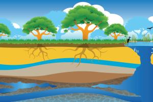
Aquifers are underground layers of rock and sand that hold water. These layers are made up of loosely packed sediments and layers of calcium-rich limestone and dolomite. In Florida, most of the population depends on the Floridan aquifer for their drinking water. The Floridan aquifer, which is the largest and deepest aquifer in the state, holds groundwater like a sponge. Holes in the rock that make up the aquifer allow the water to move freely through it. Aquifers are…
A bay is a shallow body of salt water between a larger barrier island and the mainland. A barrier island is a long, narrow sandy island parallel to the shore. Palma Sola Bay is located between the barrier island of Anna Maria and the city of Bradenton.In the 1880s, a fishing village called “Cortez” was formed here and was bustling with fishermen. It's one of the last commercial fishing villages in Florida and is on the National Register of Historic Places. Tarpon,…
The Southwest Florida Water Management District maintains and operates 84 structures throughout the District’s 16-county region. These structures help provide flood protection, manage lake water levels and prevent salt water from flowing up freshwater streams and creeks.
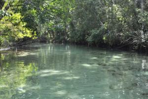
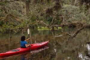
Join us in the community effort to protect the Weeki Wachee River. The Weeki Wachee River is a great place to experience natural Florida. This river flows 7.4 miles from the headspring to where it meets the Gulf of America at Bayport in Hernando County. It’s a popular spot for kayaking and boating. But increased recreational activities have had negative environmental impacts on the river. Here are some ways you can recreate responsibly and…

Both the United States government and Florida have adopted water quality goals and standards. Each water body has its own standards. For example, water used for drinking has to be much cleaner than water used for crop irrigation or to cool machinery in a factory. Scientists use information from water monitoring to determine how a water body rates based on its intended use. If scientists rate water quality as GOOD, then the water can fully support its…
The purpose of the Agricultural and Green Industry Advisory Committee (AGIAC) is to provide professional and technical input into District programs and activities. This includes regulatory programs, rule revisions, water conservation activities, water resource planning, water resource and supply development projects, research and other water resource management projects that relate to the agricultural and green industries. Subject matter considered by the…
Join us in the community effort to protect Three Sisters Springs. Three Sisters Springs is great place to experience natural Florida. It is a preferred refuge of wintering manatees during cold temperatures. It’s also a popular spot for humans to swim and kayak. But increased recreational activities have caused negative environmental impacts on the springs.…
Join us in the community effort to protect the Chassahowitzka River. The Chassahowitzka River is a great place to experience natural Florida. The river flows 5.6 miles from the headsprings to where it meets the Gulf of America at Chassahowitzka Bay in Citrus County. It’s a popular spot for kayaking and boating. But increased recreational activities have had negative…