
Both the United States government and Florida have adopted water quality goals and standards. Each water body has its own standards. For example, water used for drinking has to be much cleaner than water used for crop irrigation or to cool machinery in a factory. Scientists use information from water monitoring to determine how a water body rates based on its intended use. If scientists rate water quality as GOOD, then the water can fully support its intended uses. If, however, scientists rate the water quality as IMPAIRED, the water cannot support one or more of its intended uses.
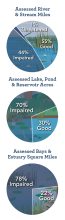
Shown at left are three pie charts comparing the quality of various water bodies. On average, about 69 percent of tested water bodies are rated as impaired.
You may notice that the pie charts are labeled as "assessed" rivers, lakes and estuaries. It would take a lot more money, technology and time than we currently have available to test all water bodies in the United States. Our country contains 3,500,000 miles of rivers and streams alone! Placed end-to-end, these water bodies could wrap around the entire earth over 140 times. Only a percent of our nation’s water bodies have been assessed: 32 percent of rivers and streams; 44 percent of lakes, ponds and reservoirs; 40 percent of bays and estuaries; 6 percent of ocean shoreline; and 87 percent of Great Lakes shoreline.
Special Section: Critical Thinking
Why do you think rivers and streams tend to be less impaired than lakes and estuaries? Water is constantly moving through rivers and streams, while lakes are areas where water collects and is stored for long periods of time. As a result, pollutants that make their way into lakes have no way of getting out.
Estuaries (a semi-enclosed body of water where fresh and salt water mix) have the highest rate of impairment. Major rivers that empty into the ocean create these estuarine habitats. Pollution can travel from hundreds of miles upstream and empty directly into the estuary.
Take a look at Tampa Bay, Florida’s largest estuary. Looking at the map, can you see how many rivers empty into this estuary? Look how far inland they run. Pollution can travel from many different areas of Florida and end up in the bay. Do you have an estuary near your home? If not, perhaps you live near a river that drains into an estuary. Now you can understand a little more the importance of maintaining clean waterways across your entire watershed (a watershed is an area of land that water flows across as it moves toward a common body of water, such as a stream, river, lake or coast).
Move on to Common Pollutants
Back to Water Quality Monitoring