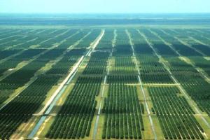
The Southern Planning Region encompasses approximately 2,465 square miles, covering all of DeSoto, Manatee and Sarasota counties and the portion of Charlotte County that lies within the District. Land-use types range from urban/built-up areas such as the cities of Bradenton and Sarasota to predominantly agricultural land uses in the inland portions of Charlotte and Manatee counties. This planning region is located within the Southern Water Use Caution Area (SWUCA).
The southern portion of Tampa Bay, the northern portion of Charlotte Harbor and all of Sarasota Bay are major coastal surface water features in the planning region. The planning region contains all or part of seven major watersheds including the Braden, Manatee, Myakka and Peace rivers, Myakkahatchee Creek (a tributary to the Myakka River), and Horse and Shell creeks (tributaries to the Peace River).
There are many smaller tributaries to these larger systems as well as several coastal watersheds drained by many small tidally influenced or intermittent streams. The Braden, Manatee and Peace rivers and Myakkahatchee and Shell creeks are utilized as public water supply sources. There are only a few named lakes in the planning region. These include Upper and Lower Myakka lakes and Lake Manatee, an in-stream reservoir on the Manatee River. There is one second-magnitude spring located within the planning region (Warm Mineral Springs). Portions of the region are dominated by extensive hardwood swamps, wet prairies and isolated wetlands.
Three principal aquifer systems (surficial, intermediate and Upper Floridan) are present in the planning region and are used as water supply sources. The 2015–2035 increase in water demand in the Southern Region is anticipated to be met by existing sources and some combination of projects using surface and reclaimed water, brackish groundwater, and non-agricultural water conservation. Reductions in agricultural water demand are very significant in the planning region due to the District’s focus on the SWUCA Recovery Strategy’s saltwater intrusion minimum aquifer level, and to improve water quality by reducing agricultural runoff in the Joshua, Prairie, Shell and upper Myakka River watersheds. The projected reduction in agricultural, mining and industrial groundwater use resulting from conservation measures and land-use transitions could be permanently retired to assist the SWUCA Recovery Strategy, and may also allow for the development of a limited amount of fresh groundwater by mitigating predicted impacts to the Upper Floridan aquifer.
