Search Content
Displaying results 1961 - 1980 of 4998
Why is the Water Management Information System (WMIS) that provides Environmental Resource Permitting (ERP) and eCompliance functions, data and documents being replaced?Although, the existing system is functional, the process is challenging, and the product lifecycle is ending. Users of the system such as District staff, external consultants and permittees often find system errors and inconsistent functionality. The completion of the ePermitting Modernization Project…
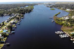
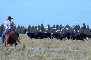
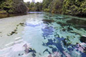
Take a journey down the Alafia River. Spanish explorers called it the Hunting River. Mocoso Indians called it River of Fire. It’s a historic water body with a prehistoric name that spans 25 miles long in west-central Florida.
Let's get started on our excursion
Register or Login for Permit Noticing by Email »
By clicking on the link directly above, account holders can subscribe to receive information by email about new applications or agency action. An email notification will be sent daily based on the criteria entered and when applicable.…
What is a Conservation Easement? A conservation easement is a legal agreement that permanently restricts the use of a portion or the entirety of a property, often as a condition of an Environmental Resource Permit (ERP). Conservation easements are recorded in the public records of the county in which the property is located. In many residential developments, conservation easements are placed over natural areas as a part of the permitting process for stormwater…
The Peace River begins in northern Polk County at the junction of Saddle Creek and the Peace Creek Drainage Canal northeast of the city of Bartow. From there, it runs approximately 105 miles south to the Charlotte Harbor estuary, where it blends with the outflows of the Caloosahatchee and the Myakka rivers. Its watershed encompasses more than 2,300 square miles and is called the Peace River Valley by locals. A watershed is an area of land that water…
Watch videos on a variety of District topics from the latest projects to water conservation initiatives. Explore District lands through virtual visits and discover how you can protect various spring systems. Plus, learn about the District’s mission, history and career opportunities.
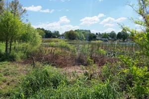
Unlike the clear, cool waters of the Springs Coast Watershed's spring-fed rivers, the Pithlachascotee is a blackwater stream that is more than 20 miles long and originates in the Crews Lake area of Pasco County. Along with the Anclote River, the locally nicknamed "Cotee" River crosses the District's Starkey Wilderness Park and meanders through Pasco County. It…

There aren’t many big predators walking around in Florida. Wolves are gone, bears are rare and panthers are nearly extinct. But in the water, it’s different. Florida’s fresh water has alligators and crocodiles — big toothy reptiles. In the ocean there are sharks — big toothy fish. Of course, gator and shark attacks are rare, but it happens enough to make us all a bit nervous.
It’s great to be able to share the state with animals that have been living here for millions of…
The Southwest Florida Water Management District manages lands under its stewardship for the protection of water resources and natural systems through the application of effective, efficient and fiscally responsible land management practices. The purposes and attributes for which the lands were acquired provide the foundation for designating the appropriate land use and management strategies on the lands. As stewards of more than 343,000 acres of land within the its 16-county…
Have you ever seen a bald eagle in flight or watched a group of river otters playing in the water? These are just a few of the creatures you may see walking along one of the trails at Oscar Scherer State Park, which offers 1,400 acres for visitors to explore and experience the real Florida.The area includes two special plant upland communities of pine…
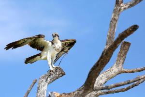
Osprey »
The osprey, or sea eagle, is a large bird of prey that is commonly seen circling above lakes, rivers, streams and ponds, or perched on dead trees (also known as "snags") or telephone poles. It is almost the size of an eagle and is dark brown with a white head and a brown mask from the eyes down to the cheeks. It also has a white and brown breast and underside. The osprey has large talons that allow it to "fish" by diving down and gripping onto fish. Additionally, the…

View Land Currently for Sale »The District has parcels for sale as part of its surplus lands program. Many of these parcels will be sold “as-is,” and others will be sold with the District retaining a conservation easement with certain restrictions. If you are interested in purchasing one or more of these parcels, contact the District’s Real Estate Section at (352) 796-7211.Why Does the…
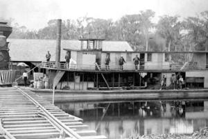
The history of the Withlacoochee River watershed is important because it is still being impacted by how people used the land as far back as the 1800s.Awareness of the river grew around the 1830s and 40s, during the 2nd Seminole War. During the war, shallow-draft steamers were used to transport materials and men on the river. Then, the late 1800s brought several booming industries to the area, including phosphate, timber and produce…
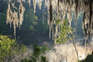
The 7.5 mile-long Weeki Wachee River is another spring-fed river on the Springs Coast. Its headwater is Weeki Wachee Springs, one of Florida’s legendary roadside attractions where tourists, including Elvis Presley, have been coming to see the famous live mermaids in the underwater theater since the 1940s. The headsprings and surrounding land are now owned by the Southwest Florida Water Management District and managed by the Florida Park Service as Weeki Wachee Springs State…
March 14, 2025The Southwest Florida Water Management District (District) is committed to providing a website accessible to the public, regardless of disability. To further this commitment, the District uses a web scanning service to assist with website accessibility and optimization. The District follows the Web Content Accessibility Guidelines (WCAG) 2.0, level AA technical standard, and is currently working toward achieving conformance with the…
As bureau chief of the Engineering & Project Management (EPM) Bureau at the Southwest Florida Water Management District, Scott Letasi is responsible for the District’s cooperative funding initiative program and District initiatives projects specifically related to the District’s flood protection area of responsibility. The EPM Bureau develops surface water models in the Watershed Management Program and implements the District’s Structures Capital Improvement Program…
As bureau chief of Information Technology, Tom Hughes is responsible for leading and managing the District’s Information Technology Bureau. The bureau works closely with internal and external customers to provide a comprehensive set of information technology services that support the District’s mission to protect water resources, minimize flood risks, and ensure the public’s water needs are met. These activities include the management of the hardware, software and data that…
Southwest Florida Water Management District
- Springs in West-Central Florida
- Recreation on District Land
- Lower Floridan Aquifer Exploration
- Minimum Flows and Levels (MFLs)
- …

Mission StatementOur mission is to protect water resources, minimize flood risks, and ensure the public’s water needs are met.Core Values
- Service Excellence
- Teamwork & Collaboration
- Self Management
- Professional Integrity
- Professional and Technical Excellence
The District is initiating an update to its Land Use Rules to allow for improved efficiency, protection of its resources and uniformity among other water management districts.A virtual workshop will be held Tuesday, December 1 at 5:30 p.m. Find out more »The District will be accepting public comment below on the draft Land Use Rulesupdate through December 7.