Search Content
Displaying results 181 - 200 of 4756
The Hydrologic Conditions Report provides an excellent historical record for long-term local and regional hydrologic analysis.
The Hydrologic Conditions Report is generated monthly and provides an analytical summary of regional and temporal variations in the hydrologic conditions for planning and regulatory purposes. In addition, it provides an excellent historical record for long-term local and regional hydrologic analysis.
Data collected are used by the regulatory,… Read more

Each year, public supply utilities must estimate the populations within their service area.Utilities also use population projections in the calculation of future water demand for planning and permitting purposes. View the following demographic resources that the District makes available to utilities:Section A to review your utility’s service area map… Read more
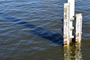
To improve accuracy, the Southwest Florida Water Management District (District) has upgraded the datum used to record water level elevation.
The District has upgraded the datum, or starting point, used to record water level elevation at its data collection sites. Water elevation is measured in feet above mean sea level.
The datum was upgraded from the National Geodetic Vertical Datum of 1929 (NGVD 29) to the North American Vertical Datum of 1988… Read more
Highlights
- System of 19 interconnected lakes, made up of two major groups; five in the northern chain and 14 in the southern chain
- Lakes were interconnected through the construction of canals to promote commerce
- Located in Polk County
- 32-square-mile watershed
- Nutrient loading from urban runoff
- … Read more
January 2024Q: What is a prescribed burn?A: A prescribed burn, also known as a prescribed fire, is a fire intentionally ignited by land managers to meet specific land management goals and objectives. The burns follow a written prescription, which outlines the defined fire treatment area, specific weather conditions that are required, the tactics staff will use, and the staffing and equipment resources that are required to safely conduct the… Read more
Your Questions Answered
March 2021
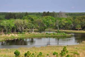
During the past year, we’ve come to appreciate the recreational opportunities of natural Florida like never before. The Weeki Wachee River is one of those breath-taking jewels people love to visit. This river flows about 7 miles from the headspring to where it meets the Gulf of Mexico at Bayport in Hernando County. It’s a popular spot for kayaking and boating, but a recent study found certain recreational… Read more
To meet Polk County’s future water needs, the District and county will be investigating the Lower Floridan aquifer as a potential alternative water source. BackgroundPolk County has traditionally relied on fresh groundwater from the Upper Floridan aquifer as aprimary water source for public, agricultural and industrial uses. The District’s 2015 Regional Water Supply Plan identifies a 22 percent increase in water supply will be needed to meet future demand in Polk County… Read more
Your Questions Answered
August 2019
Setting prescribed fires in controlled settings can reduce the risk of wildfires burning out of control, as many Floridians witnessed during the state’s wildfire emergency in 2017. Chris Reed, Land Management Manager for the Southwest Florida Water Management District, explains why the District’s prescribed burn efforts are critical to keeping Florida’s ecosystem in balance.
Q: What is a… Read more
What is a datum?
A datum is a standard position or level (i.e., starting point) from which measurements are taken.
What is the National Geodetic Vertical Datum of 1929 (NGVD 29)?
Originally called the Sea Level Datum of 1929, it was created for vertical control surveying in the United States. This datum was used to measure elevation above (altitude) and depression below (depth) mean sea level. However, as technology improved and the demand for… Read more

Project Summaries
Project summaries provide insight into project details as well as final results of campaigns, studies, pilots and programs that the District funds.
Florida-Friendly Fertilizing
2011 Year of Study
The "Florida-Friendly Fertilizing" campaign's goal was to increase District residents’ knowledge about proper fertilizing procedures and the negative aspects of over-fertilizing or failing to follow package directions. A resulting… Read more
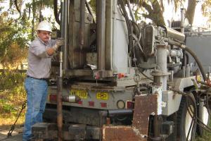
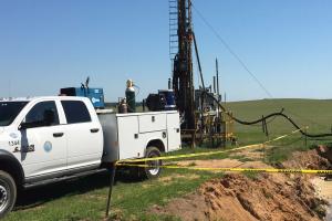
A Well Construction Permit is required prior to installation of a water well within the District. The permits ensure that wells are constructed by qualified contractors and meet rigid safety and durability standards. The rules in Chapter 40D-3, F.A.C. govern the construction of water wells and water well contractor licensing, and implement the provisions of… Read more