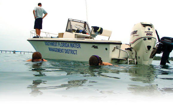
Engineer Matt Preston keeps watch from the boat, while swimmers Stephanie Powers and Mary Szafraniec, District environmental scientists, survey seagrass.
Vital Marine Habitat Shows Improvement in Six Water Bodies
Increases in seagrass presence in the Tampa Bay and Charlotte Harbor regions have given District scientists encouraging signs that the health of some important water bodies is continuing to improve.
The Surface Water Improvement and Management (SWIM) Program recorded an 11 percent increase in seagrass growth in Tampa Bay since 2008, documenting the largest extent of seagrass since the District began the seagrass mapping program. The District study also shows gains in the greater Tampa Bay area’s St. Joseph Sound and Clearwater Harbor, as well as in Charlotte Harbor and nearby Lemon Bay and Sarasota Bay.
Seagrass is an important marine habitat and a valuable tool for scientists throughout the state of Florida. Seagrass generally grows in waters less than six feet deep, but can be found in local waters as deep as 15 feet. Seagrass is an important barometer of a bay’s health because it requires relatively clean water to flourish and serves as “the nurseries of the bay,” sheltering and supporting a variety of juvenile fish and other marine creatures.
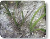 A patch of seagrass thrives in Sarasota Bay.
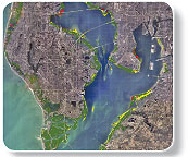 Tampa Bay seagrass mapping indicates status as holding (green), losses (red) and gains (yellow).
According to the District’s 2010 seagrass mapping study, seagrass acreage in the three Tampa Bay area water bodies has increased 3,313 acres since 2008. Tampa Bay, St. Joseph Sound and Clearwater Harbor now support 50,382 acres of seagrass. Tampa Bay saw the largest increase: 3,250 acres. The St. Joseph Sound and Clearwater Harbor areas recorded a combined 62-acre increase in seagrass.
South of Tampa Bay the results are similar. Seagrass acreage in Lemon Bay, Sarasota Bay and Charlotte Harbor increased 960 acres. All together, the three water bodies now support 33,838 acres of seagrass, more than at any time measured since the 1950s. Lemon Bay saw a 6.1 percent increase, Charlotte Harbor seagrass increased by 4.2 percent and Sarasota Bay increased slightly by 0.4 percent.
Kris Kaufman, a District environmental scientist, said that both seagrass acreage and water quality have shown improvements.
“We’ve analyzed more than 20 years of data and found significant increasing trends in seagrass cover over time,” said Kaufman. She cited several factors that could have contributed to gains in seagrass growth.
“Current digital mapping technologies that provide the highest quality data, in coordination with extensive fieldwork, can improve the detection of seagrass and biannual changes in seagrass,” said Kaufman. “Also, overall lower rainfall since 2006 means less stormwater runoff flowing into the bay, contributing to the clearer water noted over the last few years.”
In addition to monitoring seagrass resources, SWIM is also charged with conducting restoration projects funded in part by the District.
“Since the seagrass monitoring program began in the late 1980s, the communities around the District’s SWIM Program priority water bodies have experienced impressive improvements in wastewater and stormwater treatment,” said Jennette Seachrist, District SWIM Program manager. “The District is working hard to implement regional stormwater improvement projects that reduce pollution entering these water bodies.”
As part of the seagrass mapping program, SWIM scientists assess seagrass coverage in five gulf coast estuaries. Every two years maps are produced from aerial photographs and then verified for accuracy by conducting field surveys. The results are used to track trends in seagrass in estuaries throughout southwest Florida and to evaluate ongoing water quality improvement efforts.
For more information about the District’s SWIM Program, please visit the District’s website at WaterMatters.org/swim/ .