Search Content
Displaying results 2781 - 2800 of 5101
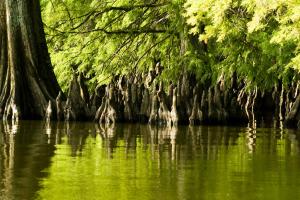
The Chassahowitzka Springs Restoration Project improved water quality and the bottom habitat for plants and animals. Project OverviewThe Southwest Florida Water Management District restored portions of Chassahowitzka Springs by removing accumulated sediments, which improved the water quality and the bottom habitat for plants and animals.BackgroundSand and organic materials have been transported by flows from residential canals and stormwater runoff to the springs and…
About the Watershed Management ProgramThe District takes a watershed approach to managing water and water-related resources within its boundaries. By doing so, all the characteristics of each watershed can be evaluated to reflect the real, interconnected nature of Florida’s water resources. This increases the District’s ability to clearly identify, prioritize and address issues related to the area’s water resources. The Watershed Management Program provides a method to…
Left: Range Master Bill Rappleyea, right, and Teagan Harris demonstrate shooting technique. Right: Tyler Smith, left, and Austin Vice retrieve their arrows after a contest.
Thanks to some help from the District, a new 4-H Club is getting off the ground in Sumter County.
The Sumter County 4-H Club is using the District’s Lake Panasoffkee property to…
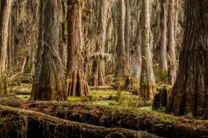
The beat of central Florida’s hydrologic heart lies between Tampa and Orlando in 560,000 acres of Florida backcountry called the Green Swamp. The Green Swamp includes portions of Polk, Lake, Sumter, Hernando and Pasco counties. Within these acres is a complex, integrated and delicate natural system composed of cypress swamps, hardwood forests, marshes, pine flatwoods and sandhills. Emerging from this precious oasis are the Hillsborough, Withlacoochee, Ocklawaha and…
A watershed is an area of land that water flows across as it moves toward a common body of water, such as a stream, river, lake or coast. The Alafia River watershed is approximately 270,000 acres, or 418 square miles. Although a portion of the watershed lies in Polk County, most of it lies in Hillsborough County. In fact, it’s the largest watershed in Hillsborough County.
.embed-container {position: relative; padding-bottom: 70%; height: 0; width: 150%;margin-left:-…
From left: Kevin Stover, 33 years, Field Technician Supervisor, Resource Data & Restoration. Richard Gant, 34 years, Field Technician Supervisor, Resource Projects. Kevin Love, 35 years, Manager, Land Resources. Mike Holtkamp, 35 years, Director, Operations, Maintenance & Construction Division
Five Staff Members Share Memories at a Roundtable Interview
How would you describe the District when you first started working here?
…
Fertilize Smart, Protect Our Waterways. #FertilizeSmartUnlock expert tips on fertilizing your lawn the right way—at the right time, with the right fertilizer—to keep your grass green and our water clean!Download Your Free Guide!Sign up for the Water 101 for Homeowners newsletter and get access to your free fertilizing guide instantly. Get Your Free Guide
function redirectToPDF() {
setTimeout(function() {
window.location.href…
This project will investigate the recharging of excess surface water, treated to primary drinking water standards, into the Upper Floridan aquifer more than 1,000 feet below the land’s surface. The recharged water has the potential to help improve groundwater levels and reduce the rate of saltwater intrusion from the Gulf of America in the SWUCA’s Most Impacted Area.SWUCA Recovery and Natural System ImprovementIn 2017, the District conducted a feasibility study at…
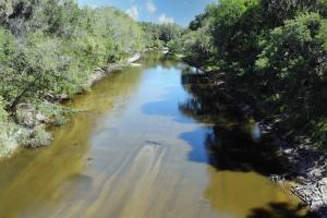
The Peace River gets its fresh water from rainfall. Annual rainfall averages approximately 53 inches, with more than half occurring between June and September. Most of the rainwater reenters the atmosphere through evaporation and plant transpiration. The rest recharges the aquifer or runs off into the Peace River and its tributary streams. The river is primarily a blackwater river. This type of river drains pine flatwoods and cypress swamps and has dark, stained waters…
The Southwest Florida Water Management District is in the process of developing the 2025 Regional Water Supply Plan (RWSP). The plan lists projected water demands as well as possible water sources for each region of the District through the year 2045. The draft RWSP is posted on the District webpage. Comments may be submitted virtually thought the webpage.…
The Southwest Florida Water Management District is in the process of developing the 2025 Regional Water Supply Plan (RWSP). The plan lists projected water demands as well as possible water sources for each region of the District through the year 2045. The draft RWSP is posted on the District webpage. Comments may be submitted virtually thought the webpage. At the workshop…
An Environmental Resource Permit (ERP) is required before beginning any construction activity that would affect wetlands, alter surface water flows, or contribute to water pollution.Environmental Resource PermitsAs authorized by Part IV of…
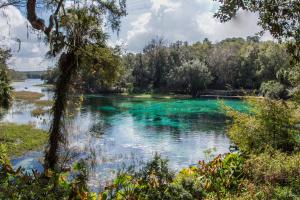
The Rainbow River in Marion County begins at Rainbow Springs in the town of Dunnellon and makes its way 5.7 miles until it merges with the Withlacoochee River. The Withlacoochee River ultimately discharges into the Gulf of America on the border of Citrus and Levy counties.Rainbow Springs has the fourth largest flow of all Florida’s springs and provides fresh water to the Rainbow and Withlacoochee rivers. The…
The Weeki Wachee Springs Restoration Project improved water quality and enhanced the overall natural system.
Project Overview
The Southwest Florida Water Management District restored portions of Weeki Wachee Springs in 2009 to improve water quality in the headspring and the upper river, as well as enhance the overall natural system.
Background
The Weeki Wachee Restoration Project was the second project aimed at cleaning up the springs.
The first project…
This project improved water quality in the Weeki Wachee River.Project OverviewThe Southwest Florida Water Management District and Hernando County made enhancements to stormwater management at Rogers Park. The park is owned by the County and located on the Weeki Wachee River. These improvements benefit the river by reducing the amount of sediments and nutrients entering the river. Project DetailsThis project uses Low Impact Development (LID) techniques to…
March 14 – 21, 2009The Southwest Florida Water Management District, together with Citrus and Marion counties and the cities of Crystal River and Dunnellon, will proclaim March 14-21 as the first Springs Awareness Week.Here is a list of events taking place during Springs Awareness Week. These events are aimed at raising awareness about the health of the local springs and what people can do to protect them.Nitrate pollution from overusing fertilizers is one reason the…
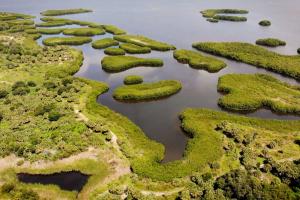
Residents and tourists have flocked to the Sarasota Bay region for years due to its remarkable natural beauty. Sarasota Bay is a subtropical estuary with a surface area of approximately 52 square miles. An estuary is a semi-enclosed body of water where fresh water mixes with salt water.The area features outstanding fishing, boating and wildlife viewing. It’s home to a wide variety of marine life, including manatees, mullet, dolphins, spotted sea trout, snook, red drum (…
A watershed is an area of land that water flows across as it moves toward a common body of water, such as a stream, river, lake or coast.The majority of people in this watershed live within 10 miles from the Gulf of America. This means that many of the activities that take place in the watershed where people live — from maintaining attractive landscapes to creating new roads and buildings — directly impact the gulf and every water body leading up to it. The Southern…