Search Content
Displaying results 221 - 240 of 5027
AGMOD is a computer program used in our water use permitting process to calculate supplemental irrigation, crop establishment, cold protection and other irrigation water uses.
The program is our main tool for allocating agricultural and recreational irrigation quantities. In addition, AGMOD has been used in the 30-year Needs and Sources Study, Water Resources Assessment Project (WRAP), District Regional Water Supply Plan, and as an alternative method for estimating annual…

White PapersWhite papers are authoritative reports or guides that help identify or solve a problem. White papers educate readers and help people make decisions. The District uses white paper research to synthesize research regarding barriers and benefits associated with target behaviors that influence water conservation and water quality. These white papers include programs that have been implemented promoting these behaviors along with strategy suggestions. …
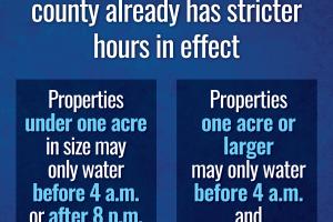
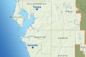
All residents remain under one-day-per-week watering restrictions with stricter watering hoursThe Southwest Florida Water Management District (District) Governing Board voted today to declare a Modified Phase III “Extreme” Water Shortage due to ongoing drought conditions throughout the region, which requires all residents, including those on private wells, to follow one-day-…
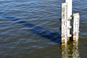
To improve accuracy, the Southwest Florida Water Management District (District) has upgraded the datum used to record water level elevation. The District has upgraded the datum, or starting point, used to record water level elevation at its data collection sites. Water elevation is measured in feet above mean sea level. The datum was upgraded from the National Geodetic Vertical Datum of 1929 (NGVD 29) to the North American Vertical Datum of 1988 (NAVD 88…
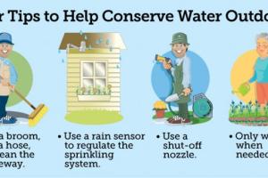
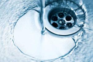
Outdoor water use typically accounts for up to 50 percent of water consumed by households. You can reduce your outdoor water consumption by taking a few simple steps.
While the District advocates water conservation year-round, an extra effort is being made to promote conservation throughout April. Governments and water management districts throughout the state have declared April Water Conservation Month because April is traditionally one of the driest months of the…
April is Water Conservation Month. This month is traditionally one of the driest of the year and marks the peak demand season for public water suppliers.
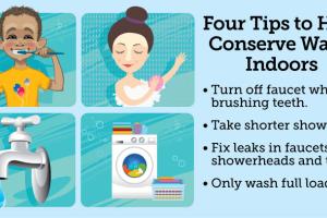
The District especially encourages conservation throughout April on top of year-round conservation. District residents can participate by being mindful of water use in their everyday household activities.
Here are some tips on saving water indoors:
- Use the home’s water meter to check…
Typically, outdoor water use accounts for up to 50 percent of water consumed by households. You can reduce your outdoor water consumption by taking a few simple steps.While the "Southwest Florida Water Management District(Southwest Florida Water Management District)":/ advocates water conservation year-round, an extra effort is being made to promote conservation throughout April. Governments and water management districts throughout the state have declared April Water…
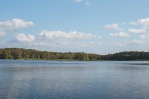
The Hydrologic Conditions Report provides an excellent historical record for long-term local and regional hydrologic analysis.
The Hydrologic Conditions Report is generated monthly and provides an analytical summary of regional and temporal variations in the hydrologic conditions for planning and regulatory purposes. In addition, it provides an excellent historical record for long-term local and regional hydrologic analysis.
Data collected are used by the regulatory,…
Outdoor water use typically accounts for up to 50 percent of water consumed by households. You can reduce your outdoor water consumption by taking a few simple steps.While the "Southwest Florida Water Management District":http://www.watermatters.org advocates water conservation year-round, an extra effort is being made to promote conservation throughout April. Governments and water management districts throughout the state have declared April Water Conservation Month because…
The Southwest Florida Water Management District’s (District) Governing Board declared April Water Conservation Month at its March meeting. April is historically one of the driest months of the year and typically marks the peak demand season for public water suppliers. The District also recently launched the Water 101 campaign to educate new and existing residents as well as communities about how they can help protect local water resources and save water and money.The…
The Southwest Florida Water Management District will be treating water hyacinth and water lettuce on portions of Shell Creek and Prairie Creek Feb. 6-9. The sites are located upstream of the Henderson Dam in Charlotte County.Treatment involves the spot application of the aquatic herbicide Reward to scattered infestations. Treated areas will be posted with warning signs displaying treatment dates and applicable water use restrictions. Water treated with Reward should not be…
The Southwest Florida Water Management District will be treating water hyacinths and water lettuce on portions of Shell Creek and Prairie Creek Dec. 12-15. The sites are located upstream of the Henderson Dam in Charlotte County.Treatment involves the spot application of the aquatic herbicide Reward to scattered infestations. Treated areas will be posted with warning signs displaying treatment dates and applicable water use restrictions. Water treated with Reward should not…
The Southwest Florida Water Management District will be treating water hyacinth and water lettuce on the shoreline and canals of Lake Panasoffkee April 11-14.Treatment involves using the aquatic herbicide Reward. Treatment areas will be posted with warning signs displaying treatment dates and applicable water use restrictions. Restrictions on Reward include no livestock watering for one day, no irrigation of turf or ornamental plants for one day or crops for five days and…
Highlights
- Lake Panasoffkee is the third largest lake (4,820 acres) in west central Florida
- Designated an Outstanding Florida Water
- Located in Sumter County
- Loss of lake area due to sedimentation
- Loss of desirable habitat for fisheries
- Increased shoreline vegetation and…
The Southwest Florida Water Management District will be treating water hyacinth and water lettuce on portions of the Braden River Feb. 13-16. The sites are located south of State Road 70 in Manatee County.Treatment involves using the aquatic herbicide Reward. Treatment areas will be posted with warning signs displaying treatment dates and applicable water use restrictions. Restrictions on Reward include no livestock watering for one day, no irrigation of turf or ornamental…
The Southwest Florida Water Management District will be treating water hyacinth and water lettuce on portions of the Braden River April 4-7. The sites are located south of State Road 70 in Manatee County.Treatment involves using the aquatic herbicide Reward. Treatment areas will be posted with warning signs displaying treatment dates and applicable water use restrictions. Restrictions on Reward include no livestock watering for one day, no irrigation of turf or ornamental…
The Southwest Florida Water Management District will be treating water hyacinths and water lettuce on portions of Shell Creek and Prairie Creek January 24-27. The sites are located upstream of the Henderson Dam in Charlotte County.Treatment involves using the aquatic herbicide Reward. Treatment areas will be posted with warning signs displaying treatment dates and applicable restrictions. Restrictions on Reward include no livestock watering for one day, no irrigation of…
The Southwest Florida Water Management District will be treating water hyacinths and water lettuce on portions of Shell Creek and Prairie Creek April 11-14. The sites are located upstream of the Henderson Dam in Charlotte County.Treatment involves using the aquatic herbicide Reward. Treatment areas will be posted with warning signs displaying treatment dates and applicable restrictions. Restrictions on Reward include no livestock watering for one day, no irrigation of…