Search Content
Displaying results 2761 - 2780 of 5101
Your Questions Answered
February 2019
Q: Is there a rainy season and dry season in central Florida?
A: Yes, rainfall is seasonal. Our rainy season is a four-month period from June through September, with average rainfall of about 7.8 inches each month. About 60 percent of our average annual rainfall is received during that time. The higher rainfall results in rising water levels in wells, lakes, rivers and springs…
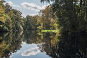
A watershed is an area of land that water flows across as it moves toward a common body of water, such as a stream, river, lake or coast. Watersheds are defined by the way water flows across the land and are shaped by features and elevations on the surface of the land.The Withlacoochee River watershed covers approximately 2,100 square miles within eight counties — Citrus, Hernando, Lake, Levy, Marion, Pasco, Polk and Sumter.…

Two officers of the District Governing Board are stepping up to new leadership roles, and two Board members are serving their first terms as officers.
The District Governing Board unanimously elected Ronald E. Oakley to serve as Governing Board chair during its May meeting. Oakley served as the Board treasurer and vice chair before his election as chair.
“I’m excited to continue to work to protect our natural resources, and I’m humbled that the Board would place so…
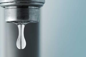
Faucets »
Check for leaks
Water losses caused by dripping faucets can range from several gallons to hundreds of gallons of water per day. Check faucets regularly for leaks at the faucet head and seepage at the base and its connections.
Fix leaks
Whether a two-handled or a single-handled faucet, leaks are repaired by replacing washers and by tightening or repacking the faucet stem. Do-it-yourselfers can find a variety of repair kits in local home improvement and hardware…

Showers »
Check for Leaks
Dripping showerheads can waste from 70 up to several hundred gallons of water a week, depending on the size of the drip. If the showerhead is leaking, make sure it is screwed tightly. Also, remember to check the washer for wear. If you need a new washer, you can get one at your local hardware store or from your plumber.
Fix Leaks
To fix a leaky showerhead, you need an adjustable wrench or pliers and joint sealer or tape. Follow these steps:…
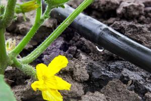
Micro-irrigation, commonly referred to as “drip” or “low-volume” irrigation, emits a lower volume of water compared to traditional sprinkler heads. Micro-irrigation delivers water directly to plant roots and is recommended for plant bed areas or potted plants, as they require less water than turfgrass.Types of micro-irrigation include:BubblersIn-Line Drip TubingMicro-SpraysPoint Source Emitters …
For Mark Brown, environmental science is more than just a career. It is his personal interest.
Brown spent part of his childhood growing up on a farm in Georgia. Influenced by his grandfather, who was a soil conservationist for the USDA Soil Conservation Service, Brown developed his interest in natural habitat protection and restoration early on.
When his family spent summer vacations in Florida, he became interested in the wide variety of natural ecosystems in the…
The Southwest Florida Water Management District (District) does not have fertilizer restrictions, but many counties and municipalities do. Check with your local government to learn if there are mandatory fertilizer restrictions or few the list below. A fertilizer blackout is a time when using fertilizers containing nitrogen and phosphorus are prohibited, usually during the rainy season. Heavy rain can wash fertilizers, especially granular ones, from lawns to streets,…
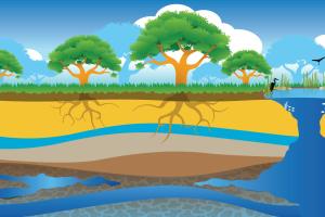
Aquifer »
Aquifers are underground layers of rock and sand that hold water. These layers are made up of loosely packed sediments and layers of calcium-rich limestone and dolomite. In Florida, most of the population depends on the Floridan aquifer for their drinking water. The Floridan aquifer, which is the largest and deepest aquifer in the state, holds groundwater like a sponge. Holes in the rock that make up the aquifer allow the water to move freely through it. Aquifers are…
The Splash! school grant program provides up to $3,000* per school to enhance student knowledge of freshwater resources issues. Public and charter school teachers of grades K-12 are eligible to apply. Grant applications for the 2025-2026 school year are now closed.Getting Started Use the links below to learn more about implementing a Splash! school grant. Please note that Splash! grants are only available to educators within the Southwest Florida Water Management…
Hog hunters from Hernando County (left to right) Wade Jenkins, Jason Bibeau and Chris Bibeau.
District land managers say a series of hog hunts held on District lands this winter and spring helped reduce the wild hog population. Hundreds of hogs were removed from seven different tracts of land throughout the District.
The District opened the land for hunting because wild hogs cause extensive damage to the natural habitats. Wild hogs, which are not native to…
Florida’s coastal ecosystems are among the most diverse in the world. At the heart of these ecosystems is seagrass—a vital underwater plant that supports marine life, improves water quality, protects shorelines and stores carbon.Since 1988, the Southwest Florida Water Management District (District) has mapped seagrass to help guide decisions that protect and sustain our bays, estuaries and coastal waters. But how exactly is seagrass mapped and why is it important? The…
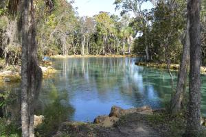
A spring is a place where groundwater discharges from the underlying limestone bedrock to the Earth's surface through a natural opening in the ground. In the Springs Coast Watershed, the Floridan aquifer is close to the land surface, which means that the springs are exposed portions of the aquifer! As windows into the aquifer, springs have long been one of Florida's most valued natural and scenic resources. In 1513, the Spanish explorer Ponce de Leon came to Florida in…

Does the District forecast river flooding?The District does not forecast river flooding. We refer to the Southeast River Forecast Center, an agency of the National Weather Service. The public can use their interactive map to view forecast locations experiencing flooding and links to detailed forecast information. The National Weather Service also establishes flood stage categories and thresholds. While local news sources…
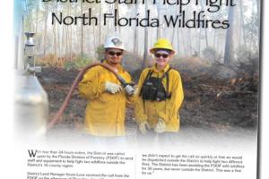
Brian Townsend, District senior heavy equipment operator (left), and Stephanie Green, senior land management specialist, supported the Florida Division of Forestry at the Santa Fe fire.
With less than 24 hours notice, the District was called upon by the Florida Division of Forestry (FDOF) to send staff and equipment to help fight two wildfires outside the District’s 16-county region.
District Land Manager Kevin Love received the call from the FDOF on the…
As bureau chief of General Services, Dave Dickens oversees the District’s Document Services, Public Records, Fleet Services and Facilities sections.Dave has 12 years of experience managing transportation, facilities and safety programs for water management districts in Florida.He most recently served as the Transportation and Facilities Bureau chief for St. Johns River Water Management District, where he managed budget, procurement, capital projects and contract management.…
As the assistant director of Resource Regulation, Brian Starford is responsible for the division’s production. This includes establishing performance metrics for Resource Regulation’s critical functions and monitoring those functions to ensure that established performance expectations are met. Starford also assists the director with the administration of the division’s permitting and compliance operations.Starford began his career at the District in 1987 as a water resource…
Geology »
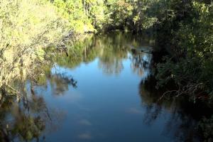
The Alafia River watershed is a textbook example of karst topography. A karst terrain is produced by acidic water dissolving the underlying bedrock (mostly limestone).
Springs are a common feature of karst topography. A spring is a natural opening in the ground where water flows directly from the aquifer to the earth’s surface. Florida has the largest concentration of springs in the world. Lithia Springs and Buckhorn Springs…
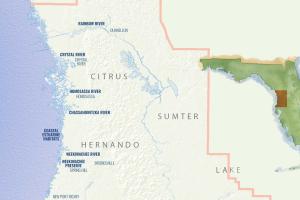
Some of the cities and towns located in the Springs Coast Watershed include Brooksville, Crystal River, Dunnellon, Homosassa, New Port Richey and Spring Hill. The trademarks of this watershed are the many springs that discharge to form rivers, the extensive coastal swamps and salt marshes, high pine woodlands and lakes.There are more than 200 documented springs that occur throughout the Southwest Florida Water Management District (District). Five of these have a discharge of…
Bartow, Fla., July 11, 2017 — Drilling more than half a mile below ground to find new sources of water in the Lower Florida aquifer (LFA).
Finding new ways to reuse reclaimed water.
Combining stormwater and reclaimed water to build a sustainable supply.
These are some of the innovative projects the Central Florida Water Initiative (CFWI) is developing to meet the growing water needs of the five-county Central Florida region while also…