Scientists with the District’s Surface Water Improvement and Management (SWIM) Program are optimistic about an overall increase in the growth of seagrass in Tampa Bay, as well as nearby Sarasota Bay, Charlotte Harbor and St. Joseph Sound.
Seagrass generally grows in waters less than six feet deep and is an important barometer of a bay’s health because it requires relatively clean water to flourish. Seagrass beds serve as “nurseries of the bay,” sheltering and supporting a variety of juvenile fish and other marine creatures. For example, snook and red drum use seagrass beds as feeding grounds and habitat.
The District’s newly released 2006 seagrass maps show Tampa Bay has gained nearly 1,300 acres of seagrass since 2004, which is a 4.7 percent increase. Tampa Bay now supports more seagrass than at any time measured since the 1950s. Sarasota Bay saw an increase of 7 percent during the same time period.
The District began a formal mapping program in the late 1980s and produces seagrass maps every two years. The District uses consultants to complete these projects. Several state and local agencies also provide assistance with logistics because the projects span such large areas.
SWIM scientists assess seagrass coverage in Tampa Bay every two years using a combination of maps produced from aerial photographs and field surveys to verify accuracy. The results are used to track trends in seagrass in estuaries throughout southwest Florida and to evaluate ongoing water quality improvement efforts.
“Technologies are constantly evolving, so we took advantage of digital imagery to capture the latest seagrass photography,” said Kris Kaufman, a District environmental scientist.
The digital images were taken in February 2006. Good water clarity and higher resolution imagery may have contributed to mapping deeper-water seagrass beds for the first time along Egmont Key and Sarasota Bay.
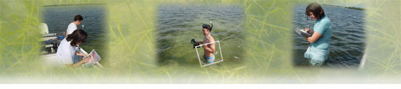
Once the aerial survey is taken, the data is processed and interpreted into a geographic information system (GIS) map. To correctly identify seagrass in the images, District scientists Kaufman and B. J. Grant worked closely with the consultant to field-verify any questionable areas. The two conducted field surveys in the summer and fall of 2006.
“Field verification eliminated some areas that had previously been mapped as seagrass but were actually thick mats of algae or some other anomaly,” said Kaufman.
The map was finalized in the winter of 2006 except for some extra fieldwork needed to verify hard-bottom communities in Tampa Bay.
Results of the 2004–2006 surveys show that Tampa Bay is regaining seagrass overall at a rate of two to three percent each year.
In addition to an overall increase in seagrass, water clarity in Tampa Bay is also the best it has been since record-keeping began in the 1970s. Data on water clarity is collected by the Hillsborough County Environmental Protection Commission from more than 60 sampling stations scattered throughout the bay.
The largest gain in acreage was seen along St. Petersburg in Boca Ciega Bay. Another important area of Tampa Bay with measurable improvements in seagrass coverage was the area north of the Gandy Bridge. This area experienced a 16 percent increase in seagrass from 2004 to 2006. That’s good news because the area had been steadily losing seagrass for a decade.
“Results of our seagrass mapping project indicate SWIM and other stormwater improvement projects are on the right path toward a healthier bay,” said Jennette Seachrist, SWIM Program manager. “The work to reduce nutrient loading and improve water quality will continue to be a priority.”
Although the overall “report card” on the bay’s health is positive, not all bay segments experienced seagrass expansion. Significant declines were noted in Middle Tampa Bay and in Hillsborough Bay.
The Tampa Bay Estuary Program has set a goal of restoring seagrass baywide to the levels at which they were present in the 1950s, roughly 38,000 acres. The bay currently has 28,299 acres.
The next SWIM seagrass mapping project will kick off in December with the beginning of new digital aerial photographs. The project encompasses all five estuaries, from Boca Grande to Tarpon Springs.
Meanwhile, District staff is currently working on a similar mapping project from the mouth of the Anclote River near Tarpon Springs to the mouth of the Withlacoochee River. This northern coastal project is a cooperative effort among the District and the Florida Fish and Wildlife Conservation Commission (FWC). The District is using digital imagery of the area taken by the FWC in the spring of 2007. From there, a consultant will process the data and interpret it into a GIS map. The maps are expected to be available in the spring of 2008.