Search Content
Displaying results 2701 - 2720 of 5109
The Southwest Florida Water Management District Governing Board Tuesday adopted its proposed Fiscal Year 2009 (FY2009) millage rates for the General Fund and the eight Basin Boards.The Governing Board adopted a proposed FY2009 millage rate of 0.3866 mill for the District’s General Fund, which is the same as the current fiscal year. FY2009 will run from Oct. 1, 2008, through Sept. 30, 2009.The total proposed FY2009 budget for the District is $375.8 million, 4.9 percent…

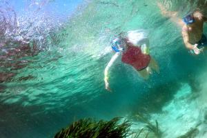
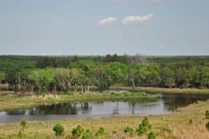
We all live in a watershed. That means that what we do on land impacts water bodies both near and far. To protect our water resources, we all must do our part. And sometimes that means preserving habitats that naturally protect water bodies from harmful pollutants, such as our wonderful wetlands!
What are wetlands?
The term wetland refers to a wide variety of aquatic habitats. Wetland ecosystems include swamps,…
Todd Pressman was elected Wednesday by his peers to serve as Governing Board chair of the Southwest Florida Water Management District.Other Governing Board officers selected today include Ronald E. Oakley, vice chair; Hugh Gramling, secretary; and Sallie Parks, treasurer.Chair Todd PressmanPressman of Oldsmar was first appointed to the Governing Board in April 2005, and is also co-chair ex officio of the District’s Pinellas-Anclote River Basin Board. He has also served…
Project WET (Water Education Today)Empowering educators to engage youth to understand water and solve local and global challenges.The Project WET Foundation develops water education resources, provides educator workshops, organizes special water events and has a worldwide network of educators and partners. To learn more about Project WET visit ProjectWET.org. Project WET Educator WorkshopsThe Southwest Florida…
WUP Introduction
A quick introduction to the Southwest Florida Water Management District’s Water Use Permitting (WUP) program and instructions on becoming an online registered user.
What is ePIC
A quick introduction to the Southwest Florida Water Management District’s new Online Water Use Permit Information Center (ePIC).
Intro to ePIC
An instructional video for utilizing the Southwest Florida Water Management District’s new Online…
Left: Donna Holdrege, District administrative supervisor, left, and Mary Torrusio, District senior communications coordinator, second from left, demonstrate a watershed model to students. Right: Dan Wolthuis, District senior heavy equipment operator, talks to students and parents about prescribed fire.
Parents marked the District’s 15th annual celebration of Take Our Daughters and Sons to Work Day on April 18 by bringing their children for tours of District…
Assisting the agricultural community by improving the quality of ground water used for irrigation.
Existing wells located in the District’s southern and coastal areas often exhibit water quality conditions that are more highly mineralized with increased well depths. The use of highly mineralized ground water for irrigation purposes can adversely affect both agricultural yields and the water quality of downstream receiving water bodies. Efforts to reduce mineralized…
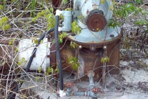
What is a spring? A spring is a natural opening in the ground where water flows directly from the aquifer to the earth’s surface. The source of this fresh water is from seasonal rainfall that soaks into the ground, which is referred to as groundwater. Springs form when groundwater is under pressure and flows up through an opening called a spring vent, supplying flow to a river or other water body. A spring can occur individually or as a group of many springs. The most…

An efficient irrigation system is designed to deliver the appropriate amount of water to match the needs of turfgrass and plant beds. Irrigation ZonesAn in-ground irrigation system typically waters the landscape in sections instead of all at once. These different sections are referred to as “irrigation zones.” Properly designed irrigation zones are important for three key reasons:
- Not all plants within the landscape need the same amount of water.
- …
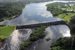
OverviewMinimum flows are limits established by the District’s Governing Board for surface watercourses to prevent significant harm to the water resources or ecology that may result from water withdrawals. Florida Statutes require the development of a recovery strategy when existing flows fall below the applicable minimum flow. The District has established minimum flows for the Lower Hillsborough River to help protect the river’s ecological health…
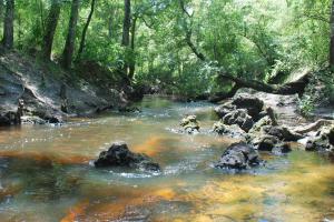
KarstMuch of Florida’s landscape is composed of “karst” landforms. Karst terrain is a land surface produced when bedrock — mostly limestone in Florida — dissolves slowly over time as acidic rainwater passes through it. Karst terrain provides a direct connection between surface waters and groundwater and is characterized by springs, sinkholes and caverns.Springs Springs are a common feature of karst topography. They also serve as key tributaries of the…
As assistant executive director, Mandi Rice oversees the day-to-day operations of the District’s five divisions: Resource Management, Regulation, Business & IT Services, Employee, Outreach & General Services, and Operations, Lands & Resource Monitoring.Before joining the District, Rice worked at Tampa Bay Water, Florida’s largest wholesale water supplier, for 18 years in various positions including project manager, senior manager of construction and, most…
Projects of Distinction
The Tampa Bay Regional Planning Council recently recognized the District during its 13th Annual Future of the Region Awards program.
One District Surface Water Improvement and Management (SWIM) project and two education projects were honored during the ceremony, recognizing notable achievements in resource planning and management in the region.
Port Redwing Habitat Restoration/ Fred & Idah Schultz Preserve
The…
Hundreds of volunteers trudged through the mud to get to hard-to-reach places that needed planting.
This September approximately 400 volunteers set out across 32 acres of muddy ground at the Terra Ceia Aquatic and State Park preserves restoration project in Manatee County with one goal in mind: The volunteers were determined to set a new record for the most plants installed during a…
Volunteers participating in cleanup.
More than 50 District employees, Board members and their friends and families were among the hundreds of volunteers taking part in the 21st Annual Hillsborough River & Waterways Cleanup.
This annual event, held in November, is one of Tampa’s largest volunteer activities. Each year, volunteers scour dozens of shoreline locations along the Hillsborough River and connected waterways to pick up litter and remove…
The Rock Ponds Ecosystem Restoration Project has become a showcase project for habitat restoration through community partnerships. That’s why the project was just recognized by the Tampa Bay Regional Planning Council. The District won first place in the Natural Environment category in the Future…