Search Content
Displaying results 61 - 80 of 2280
The Southwest Florida Water Management District is currently developing new minimum flow standards for the Upper Peace River. Minimum flows are intended to prevent significant harm to the water resources or ecology of an area that may be caused by water withdrawals. The draft minimum flows report for the Upper Peace River,…
The Southwest Florida Water Management District is currently developing new minimum flow standards for the Upper Peace River. Minimum flows are intended to prevent significant harm to the water resources or ecology of an area that may be caused by water withdrawals. The draft minimum flows report for the Upper Peace River,…
Highlights
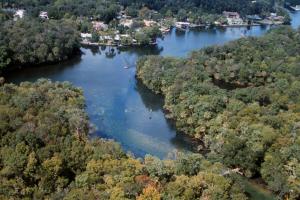
- Homosassa Springs is the headwaters of the Homosassa River and is known as the Homosassa Springs State Wildlife Park
- The park serves as a rehabilitation center and refuge for orphaned or injured manatees.
- Located in Citrus County
- 270-square-mile springshed
This panel meeting was cancelled due to a technical issue. The remaining meetings will continue as scheduled. The Southwest Florida Water Management District is currently developing new minimum flow standards for the Upper Peace River. Minimum flows are intended to prevent significant harm to the water resources or ecology of an area that may be caused by water withdrawals. The…
Highlights
- Weeki Wachee Springs are the headwaters of the Weeki Wachee River
- The headspring is home to Weeki Wachee Springs State Park, which features a water park and the famous underwater mermaid show
- Located in Hernando County
- First magnitude spring: 260-square-mile springshed
- Potential decrease in historic flows
- Elevated…
The Southwest Florida Water Management District is currently developing new minimum flow standards for the Upper Peace River. Minimum flows are intended to prevent significant harm to the water resources or ecology of an area that may be caused by water withdrawals. The draft minimum flows report for the Upper Peace River, along with the…
To learn how to better manage the Withlacoochee River watershed, the District studied how a variety of natural environments and man-made alterations have affected the river’s behavior as well as the effects of extreme high and low water levels in the river caused by natural fluctuations in rainfall and groundwater.Years of intense research have helped scientists at the District develop a comprehensive computer model of the entire river. The model has been used to test…

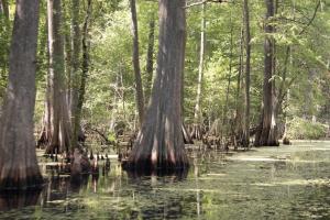
Natural Communities The Withlacoochee River watershed is comprised of a variety of natural communities, which form an extensive and diverse ecosystem. As the river begins in the Green Swamp, there are river floodplain forests, cypress domes, pine flatwoods and sandhills. The middle watershed contains extensive lake systems and marshes. Salt marsh is found as the river empties into the Withlacoochee Bay near Yankeetown. The watershed’s diverse ecosystem supports nearly…
The District celebrated the Peace River and the Peace River watershed by holding a series of events along the river during “Peace River Watershed Awareness Week” in April.
The week was recognized by the District’s Peace River Basin Board, the state legislature and participating county governments.
Each of the four events within the Peace River watershed was designed to create watershed awareness, showcase the commitment to protecting the watershed and foster proper…
March 2026Q: Why is it important to use best practices when visiting rivers and springs?A: The District has found direct links between river recreational use and environmental damage. For example, visitors leaving kayaks while on the river have trampled vegetation and eroded riverbanks and sand point bars. Also, numerous trees have been damaged from climbing and rope swinging. Over time, these actions can have negative long-term effects…

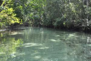
Moving southwest you will find Crystal River, which is in Citrus County and runs from the town of Crystal River west for seven miles towards the Gulf of America. Crystal River’s headwaters is an area known as Kings Bay, which has more than 70 springs. Crystal River/Kings Bay is the second largest springs group in Florida, the first being Wakulla Springs in northern Florida near Tallahassee.Many of the river's springs are 20 to 30 feet deep, and the water discharging from…
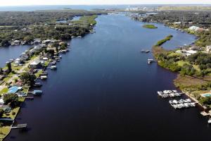
The Southwest Florida Water Management District Governing Board approved the purchase of two Peace River islands consisting of approximately 61.51 acres of uplands in Charlotte and DeSoto counties. The acquisition will be added to the 1,988 that the District owns within the Lower Peace River Corridor project.The property, commonly known as the Liverpool Islands, is located in the Peace River near the District’s Deep Creek tract. DeSoto County manages the public…
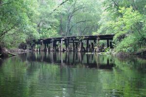
The Withlacoochee River is one of Florida’s wondrous waterways, one of the few rivers in the world flowing south to north. It is 160 miles long, starting in the Green Swamp and winding through eight different counties before discharging into the Gulf of America.The name Withlacoochee is derived from a Creek Indian word meaning Little Big Water, a likely description of the high and low fluctuations the river naturally experiences.As you travel…
Your Questions Answered March 2021During the past year, we’ve come to appreciate the recreational opportunities of natural Florida like never before. The Weeki Wachee River is one of those breath-taking jewels people love to visit. This river flows about 7 miles from the headspring to where it meets the Gulf of America at Bayport in Hernando County. It’s a popular spot for kayaking and boating, but a recent study found certain recreational activities…
Take a journey down the Alafia River. Spanish explorers called it the Hunting River. Mocoso Indians called it River of Fire. It’s a historic water body with a prehistoric name that spans 25 miles long in west-central Florida.
Let's get started on our excursion

We All Live in a Watershed
Land is very important to the water cycle and shares a strong connection to our water resources. Did you know that everything we do on land can affect the health of our water? That is because we all live in a watershed!
A watershed is any area of land that water flows across or through. Where is the water going? Downhill of course. Water in a watershed trickles and flows toward a common body of…
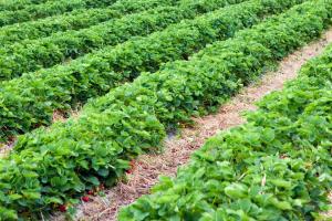
About the FARMS ProgramFARMS is an agricultural cost-share reimbursement program that reduces groundwater withdrawals from the Upper Floridan aquifer through conservation and alternative water supply best management practices (BMPs). In conjunction with water conservation BMPs, water quality and natural systems improvement BMPs also may be cost-shared in priority areas.The program is designed to serve as an incentive to the agricultural community to promote water…
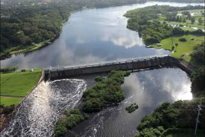
OverviewMinimum flows are limits established by the District’s Governing Board for surface watercourses to prevent significant harm to the water resources or ecology that may result from water withdrawals. Florida Statutes require the development of a recovery strategy when existing flows fall below the applicable minimum flow. The District has established minimum flows for the Lower Hillsborough River to help protect the river’s ecological health…
With nearly 30 percent of the watershed being conservation lands, there are many opportunities for recreation throughout the Withlacoochee River watershed. Many people enjoy visiting public conservation lands obtained by the Southwest Florida Water Management District and its partners to protect Florida’s water resources. The lands are open to the public for family activities such as hiking, bicycling, hunting, horseback riding, fishing, camping, nature study, paddling…