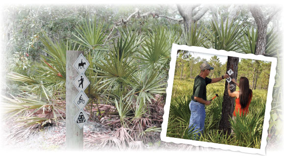
Land use specialists have completed the first phase of a major retooling of trail markings to make it easier for people to use trails on District properties.
“We needed a standardized marking system for our trails,” said Carmen Sanders, District senior land use specialist. “Developing a standardized marking system will help us lay a solid foundation as we improve the trail systems on our properties. We want to improve the experience for visitors to our properties and make it easier to navigate the trails.”
The second phase of the trail marking projects will include creating loop trails, improving the quality of trails and directing people back to the trailheads.
“This can be a difficult task because our trail systems can be very different on various properties. We want to be consistent, yet have a plan that works for all the properties.”
Land Resources staff looked at trail marking systems from state and federal parks and the Florida Trail Association to develop a marking system that would best serve the needs of hikers on District trails. Land use specialists began marking District trails with the new system in the fall, and with more than 850 miles of hiking trails on District lands that are open to the public, it’s been quite a job.
According to Sanders, hiking is the greatest use of District lands by far. The new trail marking system was completed just in time to help celebrate Florida Hiking Trails Month in February. The Florida Department of Environmental Protection joins with the Florida Trail Association each February to encourage hikers to take advantage of Florida’s extensive trail system. Many trails on District lands are located near populated areas and are also open for bird watching, jogging, bicycling and backpacking.
Some trails that are maintained by the Florida Trail Association pass through District properties. One example is the section of the Florida National Scenic Trail that passes through the Green Swamp Wilderness Preserve. It’s the premier hiking trail on District lands. This 35-mile, hiking-only trail provides opportunities for day hikes and multiple-day backpacking trips through more than 110,000 acres of natural lands.
There are many other natural areas to see. The District owns and manages approximately 436,000 acres of environmentally sensitive lands for water resource and natural systems protection. About 2.5 million people visit District lands each year to enjoy a variety of recreational opportunities.
More information on District lands that are open to the public is published in the District’s152-page Recreation Guide. The guide features more than 50 parks and preserves in the region owned by the District and its partners. Many of these lands are maintained directly by the District and offer a very natural experience, while some of these properties are managed as county and state parks and offer a broader range of amenities. The majority of these lands offer free parking and admission.
The Recreation Guide is a free publication to all residents of the District’s 16-county area and includes detailed descriptions and a map for each property. To order a free Recreation Guide or to find out more about District lands, visit the District’s web site at WaterMatters.org/recreation/.