The District is nearing completion of its effort to upgrade the datum, or starting point, used to record water level elevation. The upgrade will improve accuracy of water elevation, which is measured in feet above the mean sea level.
Staff are projected to finish the upgrade by completing the southern regions of the District in 2016.
The datum is being upgraded from the National Geodetic Vertical Datum of 1929 (NGVD 29) to the North American Vertical Datum of 1988 (NAVD 88). The NAVD 88 datum was created due to advancements in technology to more accurately reflect the elevation of a specific point relative to other points.
This will allow water elevations collected by the District to be compared with water elevations collected by other governmental agencies and scientists with even greater accuracy. All federal agencies, including the Federal Emergency Management Agency, are required to use NAVD 88. Both the South Florida and St. Johns River water management districts also are migrating to NAVD 88. Many cities and counties such as Hillsborough County are upgrading to the NAVD 88 standard as well.
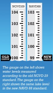
Within the boundaries of the District, the NAVD 88 elevation number is a shift of approximately .7 to 1.1 feet lower than the elevation in the NGVD 29 standard. For example, a former reading of 100 feet could be 99 feet in the new NAVD 88 standard.
Once a data collection site is converted to NAVD 88, all historic and future water level data will be published in both datum standards and made available through the District’s Water Management Information System. The datum change, which involves a surveyed recalibration of active District water-level data collection sites, is expected to be complete this year.
For more information, visit the District’s Vertical Datum Upgrade page.