Florida’s coastal ecosystems are among the most diverse in the world. At the heart of these ecosystems is seagrass—a vital underwater plant that supports marine life, improves water quality, protects shorelines and stores carbon.
Since 1988, the Southwest Florida Water Management District (District) has mapped seagrass to help guide decisions that protect and sustain our bays, estuaries and coastal waters. But how exactly is seagrass mapped and why is it important?
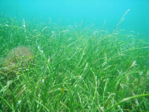
The Role of Seagrass
Seagrasses are flowering plants that grow in shallow, salty or brackish waters. Unlike seaweed, seagrasses have roots, stems and leaves. They serve as critical nursery habitats for many marine animals. About 70 percent of economically and ecologically important species, such as fish, invertebrates and marine mammals including manatees and sea turtles, spend part of their life cycle in seagrass beds.
Seagrass also supports commercial and recreational fishing by providing habitat for popular species like snook, redfish and scallops.
These underwater meadows stabilize the seafloor, reduce erosion and improve water quality by trapping sediments and filtering pollutants. They also store carbon and help reduce the impacts of climate change.
How the District Maps Seagrass
The District uses aerial imagery combined with field data to map seagrass beds. A specially equipped airplane captures high-resolution images of coastal waters. Trained staff then analyze the images to classify seagrass as either continuous (25–100 percent coverage) or patchy (10–25 percent coverage).
To ensure accuracy, field staff collect data at selected locations to verify what’s seen in the images. These mapping efforts take place every two years. The maps are used by scientists, resource managers and the public to better understand the health of our estuaries.
Tracking Trends, Guiding Recovery
Seagrass has been in global decline since the 1930s. As of 2020, scientists estimate that approximately seven percent of seagrass habitat is lost each year. Seagrass is sensitive to water pollution, coastal development and physical damage from boating. Nutrient runoff from yards, farms and urban areas can lead to algal blooms that block sunlight. Damage from boat propellers—often called “prop scars”—can take years to recover. By comparing maps over time, scientists can monitor seagrass changes, evaluate the success of restoration efforts and guide future actions.
Field Work and Public Access
District scientists collect data on key environmental conditions, such as water depth, salinity and light availability, that affect seagrass growth. Seagrass mapping data is available to the public through online interactive maps and reports. These tools help local governments, nonprofits and residents stay informed and support efforts to protect our coastal habitats.
Progress and Ongoing Challenges
There is good news. Seagrass coverage has improved in some areas, such as Tampa Bay, thanks to better water quality and long-term restoration projects. These results show what’s possible when we work together to protect our natural resources. However, challenges remain. Florida’s growing population, continued development and climate change all place pressure on coastal ecosystems.
What You Can Do
Everyone has a role to play in protecting seagrass. Here are a few ways you can help:
- Avoid anchoring on seagrass. Use mooring buoys or anchor in sandy areas.
- Limit fertilizer use. Reducing nutrient runoff helps prevent algal blooms.
- Volunteer for cleanups. Join local efforts to remove trash from shorelines and waterways.
- Support restoration programs. Partner with organizations that protect seagrass and marine life.
Protecting Florida’s Coastal Future
Seagrass mapping is more than just data collection—it’s a critical tool for protecting Florida’s coastal ecosystems. These maps help guide restoration projects, inform management decisions and raise awareness about the importance of seagrass. By working together, we can help protect these underwater meadows and the wildlife and communities that depend on them.
Learn more by visiting our Q&A Seagrass Mapping Page.