The District uses an extensive combination of research and analysis when assessing aquifer water level changes and the impacts to the state's springs, rivers and wetlands. A computer model is one of those tools used in that research and analysis.
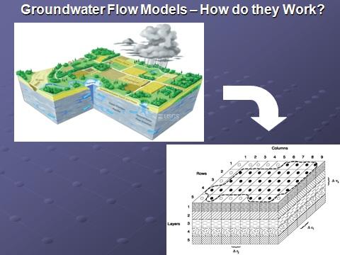
The District uses porous media models to monitor and regulate groundwater withdrawals and the impacts to resources. Porous media models are mathematical representations of a groundwater system made up of sand, clay and limestone.
Results from these types of models are reliable indicators of measured water levels and spring/stream flows, which is the primary reason the District uses these tools. Through a "calibration process," parameters in the models are adjusted so that it reproduces measured water levels in wells and recorded spring flows. This helps account for some of the unknowns in Florida's complex aquifer system.
Other Computer Models
There are other types of computer models based on a physical system made up of karst geology. But these more sophisticated models work best at a local scale where karst features, such as caverns and sinkholes, are extensively mapped and dye testing is used to determine underground flow paths. These models are typically used to examine groundwater travel times close to springs to potentially identify sources of pollution such as a wastewater disposal area or contamination site that could affect water quality.
"While these models are more advanced, there is little evidence they perform any better than porous media models when evaluating the effects of groundwater withdrawals," said Ron Basso, District senior professional geologist. "Particularly, when assessing long-term changes in flows or levels due to the impacts of many well users."
Basso said in most cases, the location and geometry of buried karst features are unknown.
"So using a more advanced model is typically unnecessary," he said. "A model that accounts for groundwater system behavior with karst features – without necessarily knowing each one's exact location - is what porous media models do."
One of Many Tools
Basso said it's important to note that a computer model is just one tool the District uses in its analysis. Staff members drill exploratory wells, collect geologic data and test the aquifer by pumping it for short periods of time. They also analyze measured flows, rainfall, withdrawals and aquifer water levels from an extensive monitoring system put in place more than 30 years ago.
The District develops its understanding of how groundwater withdrawals may impact the natural system through careful analysis of data collected in the field. Information that goes into any of these models comes from that data. This monitoring data also serves to verify whether model predictions are actually observed in the field.
The state has an extensive data collection and monitoring program that assists District scientists in evaluating water resource conditions. That system is always evolving and staff is constantly updating and refining models as new information is collected on the system.